
In the late 1970s, I walked through Camp John Hay not as a tourist. I was U.S. military, there on rest and recreation leave, and the facility had been built specifically for people like me. Pine trees, organized pathways, and a golf course that looked completely out of place in the middle of the Philippines. It was a carefully maintained American outpost in the Cordillera mountains, and it suited the purpose.
Baguio City registered with me then as a backdrop. Somewhere cool and orderly above the lowland heat. I did not yet understand what I was looking at.
That took more visits and more years. What I know now: Baguio City is not what most visitors assume when they arrive for a weekend from Manila. The cool air is real. The pine trees are real. The highland charm the travel sites describe is real. But the city carries something else underneath: a genuine argument about colonial infrastructure, Igorot survival, and what happens when mountain culture absorbs decades of outside pressure without disappearing. This article covers what I found across those visits. Not everything is flattering. That is what Baguio City deserves.
The American Military Shadow and the Colonial Buildings Still Standing
Camp John Hay was established as a rest-and-recreation facility for U.S. military personnel in 1903. The setup reflected the colonial logic of the time: a retreat at elevation, separated from the Philippine lowlands, maintained to American standards. When I was stationed in the region in the late 1970s, the camp was still fulfilling that original function. Orderly, pine-shaded, and deliberately insulated from the city surrounding it.
The U.S. handed the installation back to the Philippine government in 1991. What followed was a gradual conversion into a resort and leisure complex: golf course, hotels, heritage walking trails, and restaurants in the old club buildings. The grounds are immaculate. The mountain views from the terrace above the fairways are worth the trip on their own terms.
What I would suggest is spending a few minutes thinking about what you are walking through before settling in for a meal on that terrace. The architecture does not announce its origins loudly. The scale and the colonial planning logic of the layout do that work quietly. Knowing the history does not diminish the beauty of the place. It adds something to it.
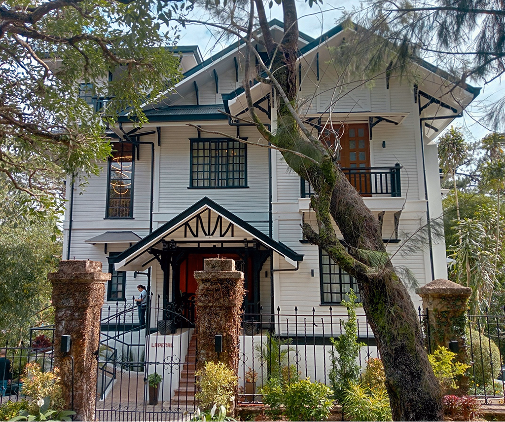
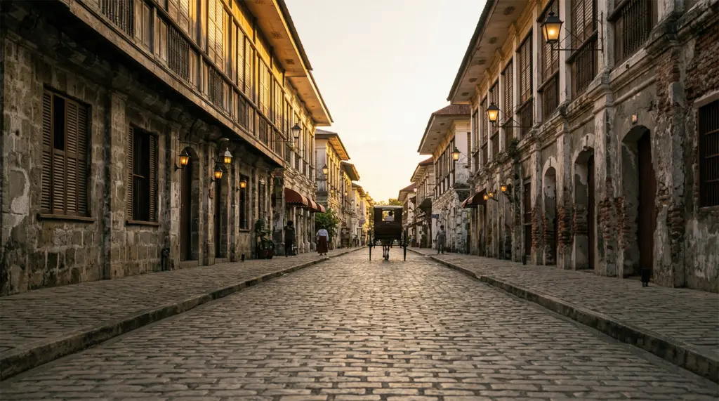
The Mansion sits nearby as the official summer residence of the Philippine president. Visitors see it from the gates, with no interior access, but the colonial architecture makes the point without a guided tour. Wright Park, adjacent to The Mansion, offers horseback riding through pine stands at a pace that Manila cannot provide. Vigan City preserved a different strand of the same colonial period. Reading that article alongside this one reveals how differently the Spanish and American legacies settled across Luzon. The Laperal White House draws visitors primarily because of the ghost stories. American colonial architecture, a documented history of tragedy, guides who lean into the paranormal with practiced enthusiasm. I went for the history. The building holds enough documented events to make the supernatural framing feel like an understatement. Walk through it with the actual record in your head. That is more than enough.
The Igorot People and What the City Was Before the Colonial Period
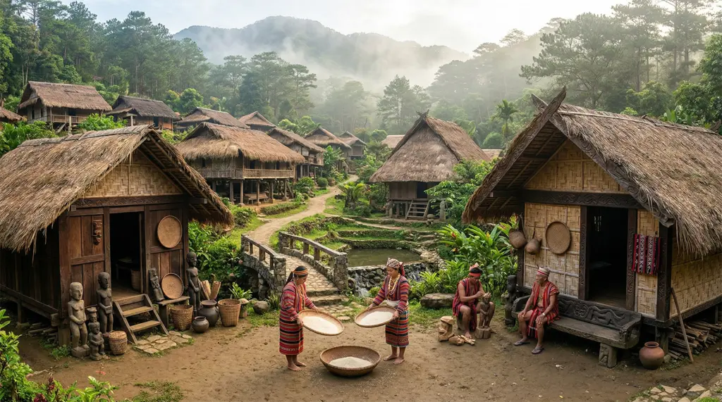
The Cordilleran peoples, the Igorot, were in these mountains long before American colonial planners decided that the elevation was useful for a military retreat. This is not the background context for the story of Baguio City. This is its center.
Tam-Awan Village exists as a working cultural space. The reconstructed traditional huts and longhouses represent Cordilleran architectural traditions, but the point is not the buildings. It is the people who work in and around them. Artists exhibit here. Craftspeople demonstrate weaving, woodcarving, and metalworking. I spent time talking with one weaver who walked me through the significance of the specific pattern she was working on. Not a generic explanation for visitors, but a precise account of what the design meant within her family’s tradition.
The woven fabrics and wood carvings at Tam-Awan Village are worth examining closely. Ask where items come from. The vendors are forthcoming if you ask whether something is locally made or imported. Igorot weaving traditions connect to a broader story of Filipino traditional crafts that spans the entire archipelago.
Mines View Park offers panoramic views of the abandoned copper and gold mines of Itogon and the surrounding Cordillera ranges. The souvenir market here carries Igorot-made craftwork alongside imported alternatives. Know the difference, and the vendors will tell you which is which if you ask. The opportunity to dress in traditional Igorot attire for photographs is available. Approach it as a genuine cultural exchange, not a novelty.
Both sites can feel touristy if you move through them at a tourist pace. Slow down. Ask questions. The Igorot cultural heritage in this part of the city is the actual story, not the backdrop.
The Market, the Food, and What Baguio City’s Altitude Makes Possible
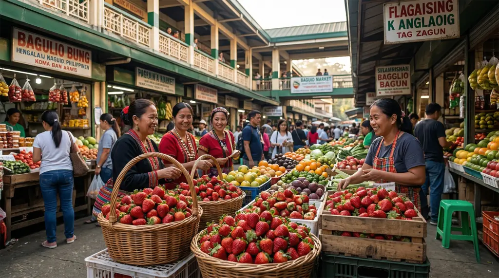
Baguio City’s agricultural context is evident in what the city eats. The altitude and cool temperatures make strawberry farming viable here in ways that are not possible in the Philippine lowlands. Locally grown strawberries appear in jam, shortcakes, fresh punnets at the market, and strawberry wine. This range registers as genuinely unusual once you understand that most berries consumed elsewhere in the country are imported. The market runs daily, and the daytime version feeds the city rather than entertaining visitors.
The food worth trying: ube jam from purple yams, Baguio longganisa, a sweet, garlicky local sausage distinct from lowland versions, panagbenga bread named after the annual flower festival, and bulalo, beef marrow soup that mountain evenings make necessary rather than merely appealing. Pinikpikan is the traditional Cordilleran chicken soup, prepared according to methods specific to the region’s cultural traditions. Order it. Understand the cultural context before forming an opinion.
The café culture along Session Road developed from the combination of a significant university population and coffee sourced from high-elevation farms in Benguet Province. The independent cafés with mountain views are worth seeking out over the chain options. For a broader orientation to what northern Luzon eats and where these flavors connect, the Luzon Island travel guide covers the regional food culture in full.
Burnham Park functions as the social center of the city. The lake, the cycling paths, and the gardens are all well-maintained. This is a public space that tells you something about what the city values. An unscheduled hour there gives you a ground-level read of the daily rhythm that no organized attraction replicates.
BenCab Museum and Why This Mountain City Produces Artists
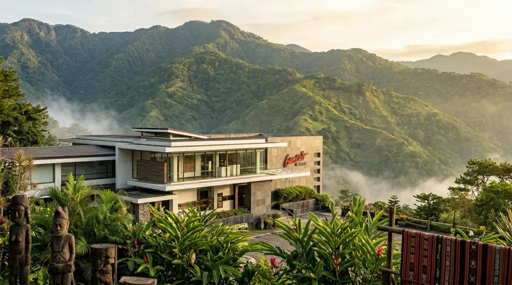
The BenCab Museum houses the collection of National Artist Benedicto Cabrera and rotates work from contemporary Filipino artists throughout the year. Cabrera built the museum here deliberately. The building is set into the hillside, with terraced gardens that open onto views of the Cordillera. The integration of landscape into the gallery experience is a design decision, not a side effect.
Baguio City has produced a disproportionate number of Filipino writers, visual artists, and musicians relative to its size. The University of the Philippines Baguio, the cool climate, the distance from Manila’s commercial pressures, and the long intersection of Igorot, lowland, and colonial cultural influences have all contributed to a creative environment that is distinct from anything the lowland cities offer.
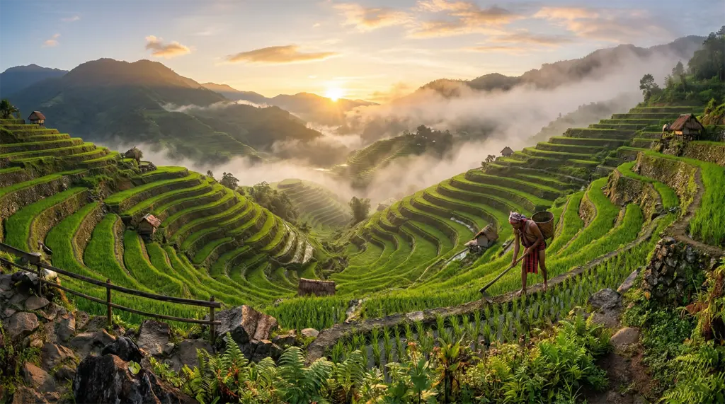
The museum grounds include a wildlife sanctuary and a café terrace with mountain views. Budget two hours. One hour will leave you feeling you should have stayed longer. The Ifugao Rice Terraces article covers the broader Cordilleran cultural heritage that provides context for much of what the BenCab collection engages.
Getting to Baguio City and the Argument Worth Having About It
The road from Manila takes approximately six hours, depending on traffic, via either Kennon Road or the Marcos Highway. Kennon Road is shorter but more demanding. It is narrow, with real drop-offs and frequent fog. The Marcos Highway is wider and more commonly used by buses. Both routes offer mountain scenery that makes the drive its own experience if you are not in a hurry.
Multiple bus lines run from Manila’s northern terminals directly here. Genesis Transport and Victory Liner are the established options, with departures throughout the day. For visitors without a vehicle, this is the practical choice. Within the city, tricycles are the standard short-distance transport; taxis and the Grab rideshare service are also available. Renting a car inside the city is generally not worth the effort. The traffic and parking situation reflects decades of infrastructure designed for a much smaller vehicle count than the one currently in use.
February brings the Panagbenga Flower Festival: floats, street dancing, market crowds, and hotel occupancy booked well in advance. The festival is worth experiencing if the density does not bother you. March through May offer the cool climate with less crowding. The rainy season runs from June through October; the mountain approach roads during this period can be slick and difficult, particularly Kennon Road.
Here is the argument: the common framing of Baguio City as primarily a weekend escape from Manila’s heat is both accurate and incomplete. The respite is real. But that frame leads visitors to spend two days on the obvious circuit and leaves them thinking they have understood what they saw.
This is a colonial military installation that became a Philippine city. It is an Igorot cultural stronghold that absorbed sustained external pressure and held significant ground. It is a creative hub with institutional roots that go deeper than most visitors ever investigate. The visitors who leave saying it was nice probably touched the surface of something that took me multiple visits across decades to begin to understand. That is not a reason to avoid it. It is a reason to arrive with a longer timeline and a genuine question about what you are walking through.
Frequently Asked Questions About Baguio City
Q1: What is the best time to visit Baguio City?
The most practical window is the dry season from November to May. March through May offer clear skies and manageable visitor density outside of the February Panagbenga Festival peak. If you want to experience the Panagbenga Flower Festival (floats, street dancing, the full market atmosphere), plan for February and book accommodation well in advance. The festival fills hotels fast, and rates climb accordingly.
The rainy season runs roughly from June through October. The city receives significantly more rainfall than the Philippine lowlands, roughly 3,000 to 4,000 millimeters annually, and the mountain approach roads can be slick and difficult during this period, particularly Kennon Road. Fog is common in the wet months and can reduce visibility on the switchbacks considerably. For visitors traveling with older family members or children, the dry season months reduce the logistical risks of the mountain approaches.
The temperature here typically ranges from 14°C to 23°C year-round, notably cooler than Manila at any season. April and early May often provide the best combination of clear skies, reasonable crowds, and the highland climate that defines the experience of being in the Summer Capital.
Q2: How do I get to Baguio City from Manila?
From Manila, the primary options are a private vehicle or a bus. By private vehicle, the drive is approximately 250 kilometers and takes five to six hours, depending on traffic. The two mountain approach routes are Kennon Road and the Marcos Highway. Kennon Road is shorter but more technically demanding. It is narrow, with significant drop-offs and frequent cloud cover that can reduce visibility. The Marcos Highway is wider, more commonly traveled, and recommended for first-time visitors.
Multiple bus companies run direct routes from Manila’s northern terminals. Genesis Transport and Victory Liner are the established options, with departures from the Cubao and Pasay terminals throughout the day. Bus travel time mirrors the drive, and it costs substantially less than a private vehicle arrangement. Within the city, tricycles are the standard short-distance transport, supplemented by taxis and the Grab rideshare service. The main bus terminal is centrally located and within reach of most major attractions.
Renting a vehicle in the city is generally not recommended, given the traffic density and limited parking throughout the center. For most visitors, arriving by bus and getting around locally by tricycle is the most practical combination. The mountain approach, whichever route you take, is part of the experience rather than a logistical inconvenience. Treat it accordingly.
Q3: What is Baguio City known for?
The city carries several distinct identities simultaneously. Most visitors know it first as the Summer Capital of the Philippines. This designation dates to the American colonial period, when it was specifically developed as an administrative and recreational center at an elevation, away from the lowland heat. The cool climate, pine trees, and mountain setting are the most visible aspects of this identity and the most common reasons first-time visitors make the trip.
Below that surface, the city is the cultural center of the Cordilleran region, the mountain homeland of the Igorot peoples, whose weaving traditions, woodcarving, and agricultural systems have persisted through centuries of colonial and postcolonial pressures. It is also known for locally grown strawberries and highland vegetables, a café culture built on Benguet Province coffee, and a significant university population that gives it a creative energy absent from most Philippine cities of comparable size.
The Panagbenga Flower Festival, each February, has become one of the major tourism events in northern Luzon. The BenCab Museum is a national cultural institution located here rather than in Manila. Its existence is a reminder that Baguio City’s creative output is not provincial in scale. Understanding all of these layers together, rather than arriving for the climate alone, is what separates visitors who leave with a real sense of the place from those who leave saying it was nice.
Q4: Is Baguio City worth visiting for more than a weekend?
Yes, and the difference between a two-day visit and a four-day visit is significant. The weekend-escape framing that most Manila-centric travel coverage applies here is accurate as far as it goes. What it misses is that two days on the obvious circuit gives you a surface reading of a place with substantially more depth.
Three to four days allows you to slow down at Tam-Awan Village and have actual conversations rather than walking through; to spend a proper two hours at the BenCab Museum rather than a rushed pass; to sit in a local café on Session Road without watching the clock; and to explore neighborhoods beyond the established tourist route. If you have a specific interest in Igorot cultural heritage, a longer stay is essential. The material available at Tam-Awan Village and from the people who work there requires time and genuine curiosity to access meaningfully.
The city also serves as a practical base for day trips into the surrounding Cordillera, including Sagada, La Trinidad, and the strawberry farms of Benguet Province. For visitors planning around the Panagbenga Festival, arriving a day before the main events and staying until after the peak crowds thin gives a more complete experience than the festival weekend alone. If your schedule allows four days here, use them.
Q5: What food should I try in Baguio City?
The short list for any visit: pinikpikan, Baguio longganisa, ube jam, fresh strawberries, and Benguet Province coffee. Pinikpikan is the traditional Cordilleran chicken soup, prepared using a method tied specifically to the region’s cultural traditions. The flavor is robust and herbal, distinct from standard chicken broth. Eating it here in its actual place of origin is different from encountering it on a Manila menu. Baguio longganisa is a local sausage with a sweet, garlicky profile that clearly distinguishes it from the many regional longganisa variations across the Philippines.
The market is the place to find both, along with ube products from locally grown purple yams, fresh strawberries from the Cordillera farms, and strawberry jam and wine. Benguet Province produces coffee from farms at elevation, and the independent cafés along Session Road typically source local beans. The flavor difference from mass-market Filipino coffee is worth comparing directly. Bulalo, a beef marrow soup, is widely available and appropriate at the temperatures the city reaches in the evenings.
Ask what is locally sourced when you order. The vendors and café staff here generally know the provenance of what they are serving and are willing to explain it. The combination of a morning at the market and an afternoon in a local café covers most of what the city’s culinary identity offers to a first-time visitor.
Q6: What is Camp John Hay, and why does it matter?
Camp John Hay was established in 1903 as a rest-and-recreation facility for U.S. military personnel. It was part of the colonial infrastructure built in the Philippines following the Philippine-American War. The facility operated in this capacity for nearly a century, remaining in American military use until 1991, when it was returned to the Philippine government as part of the broader base closure process negotiated at the time.
I visited Camp John Hay in the late 1970s while serving in the military, and the facility at that time still operated exactly as its name suggested: a retreat maintained to American standards, insulated from the surrounding city. Walking through it today, the pine trees and orderly landscaping look largely the same as I remember them. The buildings have changed. The purpose has changed. The footprint has not. The scale of the installation, the elevation above the city, and the physical separation of the original design built in are all still there.
The current camp is a resort and leisure complex: a golf course, hotels, heritage walking trails, and restaurants in the old club buildings. It is genuinely pleasant. The mountain views from the terrace above the fairways are worth the visit, independent of the history. But the visit is more interesting and more honest if you spend a few minutes with what you are actually walking through before settling into a meal on that terrace. The heritage walking trail on the grounds provides some of this context. Follow it before finding a seat.
SUGGESTIONS FOR LODGING AND TRAVEL
Lodging is widely available throughout the Philippines. However, you may want to get some assistance booking tours to some of the Philippines’ attractions. I’ve provided a few local agencies that we’ve found to be very good for setting up tours. For transparency: We may earn a commission when you click on certain links in this article, but this doesn’t influence our editorial standards. We only recommend services that we genuinely believe will enhance your travel experiences. This will not cost you anything, and I can continue to support this site through these links.
Local Lodging Assistance
- Guide to the Philippines: This site specializes in tours throughout the Philippines. They seem to have some flexibility in scheduling, and pricing is very competitive.
- Hotel Accommodations: I highly recommend The Manila Hotel for a stay in Manila. It is centrally located, and many attractions are easily accessible from there. I have provided a search box below for you to use to search for Hotels (click on “Stays” at the top) or flights (click on “Flights” at the top). This tool will provide me with an affiliate commission (at no cost to you).
- Kapwa Travel is a travel company focused on the Philippines. It specializes in customizing trips to meet customers’ needs.
- Tourismo Filipino is a well-established company that has operated for over 40 years. It focuses on tailoring tours to meet customers’ needs.
- Tropical Experience Travel Services – Tours of the Philippines: This company offers a range of tour packages, allowing you to tailor your trip to your preferences.
Lastly, we recommend booking international travel flights through established organizations rather than a local travel agent in the Philippines. I recommend Expedia.com (see the box below), the site I use to book my international travel. I have provided a search box below for you to use to search for flights (click on “Flights” at the top) or Hotels (click on “Stays” at the top). This tool will provide me with an affiliate commission (at no cost to you).
Specific Lodging Suggestions
- Grand Sierra Pines Baguio – This is a very nice hotel in Baguio. It is at the higher end of the price scale, typically at the $110 – $140 range, but it’s worth the cost.
- The Brent Guest House – This is a very nice, cozy setting typically enjoyed by couples. Prices for this location usually start at about $80 and go up from there, but it’s worth every penny.
- Log Cabin Hotel-Baguio – This is a more moderately priced hotel that is highly rated by most visitors. Prices here typically range from $45 – $130.
- Blueridge Mountain Cabin – Another moderately priced accommodation that receives great reviews. The prices here typically range between $45 – $105, but you won’t be disappointed.
Footnotes:
- Photo Attribution: Laperal White House, Baguio City
Usage Terms: Creative Commons Attribution-Share Alike 4.0 License: CC-BY-SA-4.0
Created: December 31, 2022 Author: Ralff Nestor Nacor View Original File: 3,534 x 2,952