
The first thing you notice when you drive into Mabinay from the coast is that the ground is hollow. Not literally, not in any way you can see from the road. Mabinay sits atop more than 500 documented caves. This is the largest concentration of caves in the Philippines. Once you know that, the landscape takes on a different character. The hills are not just hills. The springs are not just springs. They are the surface expressions of an underground system. That system has been moving water through karst limestone for longer than the island has had a name.
Negros Island is geologically complex, producing an unusual range of natural environments within a relatively small area. The island’s spine is a chain of volcanic mountains, with Mt. Kanlaon at the center. It is the highest peak in the Central Philippines and an active stratovolcano. As such, it reminds everyone within range that it has not finished its work. From that mountain spine, the land drops to coastal plains, river valleys, karst interior, and then the sea. Each of those transitions produces its own ecology. They have their own species assemblage, their own version of what a Philippine landscape can be.
This article covers the natural wonders of Negros Island as a whole. In addition, we’ll cover both Negros Occidental to the west and Negros Oriental to the east. The two provinces share an island and a mountain spine. At the same time, each province has a distinct ecological character that is worth understanding separately. Once they are understood separately, you will be able to better consider the island as a single natural system. The history behind those differences is covered in the companion history article. Here, the focus is on what the island looks like when you walk into it.
Mt. Kanlaon — The Volcano in the Middle of Everything
Mt. Kanlaon rises to 2,465 meters above sea level at the boundary between Negros Occidental and Negros Oriental. Geographically centered on the island, it is almost impossible to talk about either province without eventually mentioning the volcano. It is the highest peak in the Central Philippines. It is also active. Kanlaon has erupted repeatedly throughout recorded history. There were significant eruptions in 1996, 2006, and 2016, and it has been particularly restless in recent months. The Philippine Institute of Volcanology and Seismology (PHIVOLCS) continuously monitors Kanlaon. Alert levels have been elevated for extended periods during the current active phase. The mountain’s summit crater vents steam and sulfurous gases on a regular basis, even between eruptive episodes. This is not a dormant landmark. It is a working volcano, currently doing its work.
Cautionary Note
Kanlaon has been significantly active in the period leading up to the publication of this article. Please verify the current PHIVOLCS alert level and the status of any evacuation or exclusion zones before planning a visit. If Alert Level 2 or higher is in effect, the trekking information in this article should be regarded as outdated. You will need to adhere to the instructions provided by PHIVOLCS. You can check with PHIVOLCS (Philippine Institute of Volcanology and Seismology) by clicking on this link. The FAQ answer on Kanlaon safety should also be reviewed against current conditions.
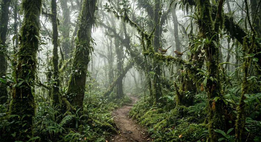
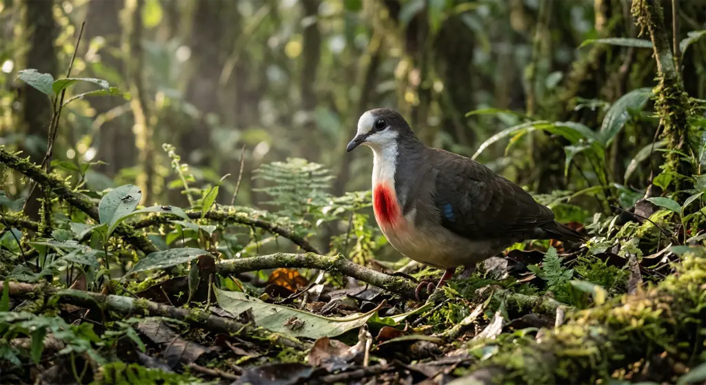
The Mt. Kanlaon Natural Park, which surrounds the mountain, encompasses 24,557 hectares of protected land. It contains one of the most intact examples of Philippine montane forest remaining in the archipelago. The park spans a vertical range from tropical lowland forest through submontane forest into montane cloud forest near the summit. Each zone contains its own distinct community of plants and animals. For example, the Negros Bleeding-heart Dove is one of the most endangered birds in the Philippines. It has a blood-red breast marking that looks exactly as described, and lives in the park’s forest interior. So does the Visayan Warty Pig, a critically endangered species found only on a handful of Philippine islands.
The Trails
Two main trail routes lead to Kanlaon’s summit. The Wasay trail starts in La Castellana, Negros Occidental, and is the more direct approach. It’s demanding and steep in the upper sections, and is used by most summit attempts. The Mapot-Mananawin route from the Negros Oriental side is longer and passes through more diverse forests. It’s typically used by trekkers who want to spend more time in the park rather than simply reaching the top. Both routes require a permit from the Protected Area Management Board. Also, summit access is suspended whenever the Philippine Institute of Volcanology and Seismology raises the alert level. Most recently, this has been occurring with some regularity. Check the current status before planning a Kanlaon summit attempt.
The park’s interior rewards time even without a summit attempt. The cloud forest zone, where the trees are draped in moss and epiphytes. The air is cooler, and visibility drops to a few dozen meters in the morning fog. It is one of the most distinctive ecological environments in the Visayas. Birdwatchers specifically come to the Kanlaon area for species found nowhere else. Specifically, the Negros Striped-Babbler, the Visayan Hornbill, and the Negros Fruit Dove. These are not incidental sightings. They are the reason serious birders make the trip.
The Caves of Mabinay — 500 Under the Ground
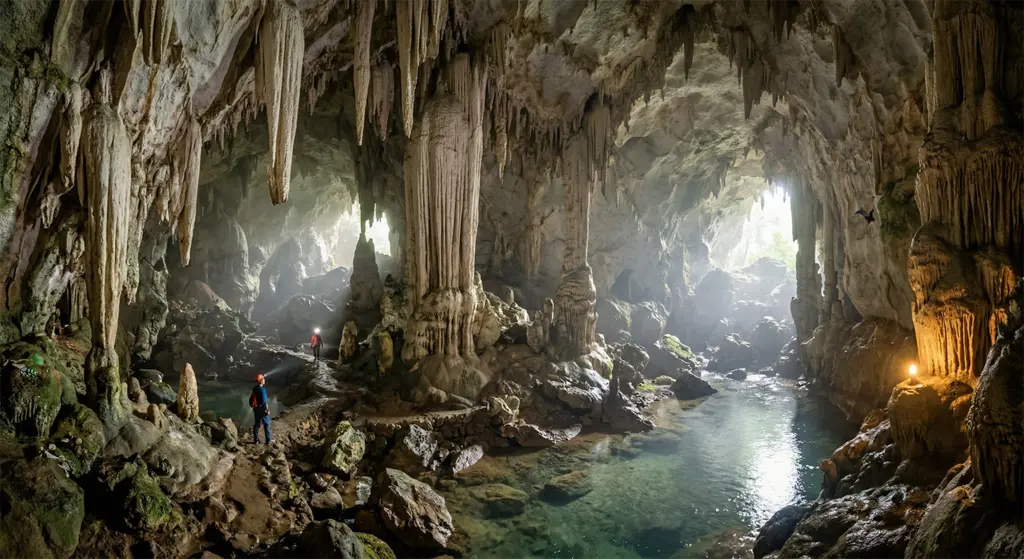
Mabinay, in the interior of Negros Oriental, sits on a karst limestone formation that contains over 500 documented caves. This is more than anywhere else in the Philippines. This is not a figure of speech or a tourist department approximation. The Mabinay cave systems have been studied by both local and international speleologists. The number of studies continues to grow as new passages are discovered and mapped. The caves range from small, accessible chambers to multi-chamber systems that require proper equipment and experience to navigate safely.
My family’s home is in Mabinay, not far from Mabinay Springs, which is itself part of the karst water system. It is a surface spring fed by the same underground network that shapes the caves. Knowing the place outside the caves makes the caves themselves more legible. The hollowed-out limestone under the town is not a geological curiosity. It is the reason the springs exist. The reason the soil drains as it does dates back to pre-colonial communities that lived in and around these hills. They were here for thousands of years before the Spanish arrived. The archaeology is there, and artifacts and remains have been found within the cave systems. They document human presence predating any written record of Mabinay.
The Caves of Mabinay
The most accessible caves for visitors are concentrated near the town center and around the Mabinay Springs area. Guided cave tours are available and strongly recommended, even for the accessible systems. The limestone formations are fragile, the lighting inside is limited, and the more interesting chambers require a guide who knows the route. Cave swimming is possible in several of the systems where underground rivers and pools have formed. The water is cold, clear, and completely unlike any other swimming experience on the island.
Mabinay does not have the tourist infrastructure of Apo Island or the profile of Kanlaon. Most visitors to Negros Oriental go to Dumaguete and the coast. That makes Mabinay what it is. It’s a genuine interior destination. One that rewards the effort of getting there and has not been optimized for mass tourism. For that, the caves are better.
The Waterfalls of Negros Island
Negros Island receives substantial rainfall; the volcanic mountain spine creates orographic precipitation on both the western and eastern slopes, and, over geological time, this has resulted in numerous waterfalls distributed across both provinces. Several are genuinely distinctive and worth the effort to reach.
Casaroro Falls — Valencia, Negros Oriental
Casaroro Falls drops approximately 30 meters into a pool in the mountains above Valencia, a municipality about 15 kilometers from Dumaguete. The falls are narrow and powerful, framed by near-vertical basalt walls and thick vegetation, and the approach involves a descent of several hundred steps into a ravine, steps that you will remember on the way back up. The payoff is a waterfall that feels genuinely remote despite being less than an hour from the provincial capital. The pool at the base is swimmable in the dry season. The trail to reach it passes through secondary forest with good birdwatching opportunities. Casaroro is probably the most-visited waterfall on Negros Oriental, and for good reason.
Pulangbato Falls — The Red Waterfall
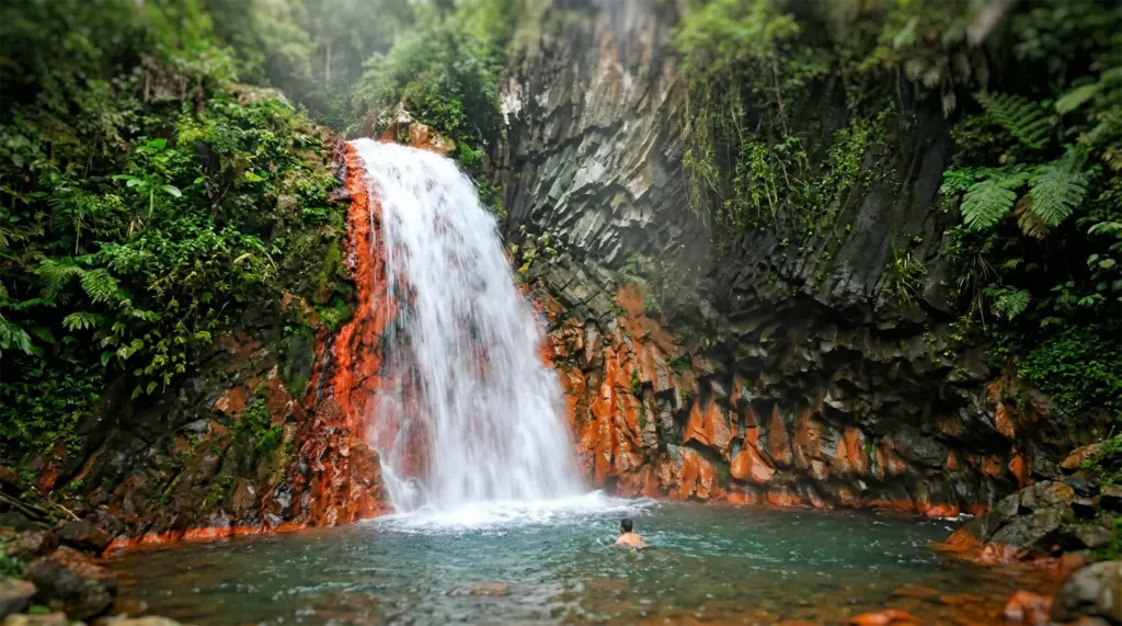
Also, near Valencia, Pulangbato Falls takes its name from its color. “Pulang bato” means “red rock” in Cebuano, and the name is accurate: the volcanic mineral content in the water has stained the surrounding rock a distinctive deep orange-red, and the cascade runs over and around formations that look unlike any other waterfall in the Philippines. The water is warm, geothermally influenced, which accounts for both the temperature and the mineral content, and the overall effect is a fall that looks as though it belongs in a landscape that has not quite finished cooling down from the upstream Kanlaon activity.
Pulangbato is less visited than Casaroro and more difficult to find without local guidance. That makes it better in most respects. The red rock formations photograph extraordinarily well in afternoon light, the warm pools are genuinely pleasant, and the sense that you have found something specific rather than following a sign to an attraction is real. If you are spending time near Valencia, visit both. They are within a few kilometers of each other and have entirely different characters.
Bugsok Falls and the Seven Falls of Kanlaon
Bugsok Falls, in Kabankalan City in the southern part of Negros Occidental, is part of a series of cascades that together form one of the more substantial waterfall systems on the island’s western side. The hike to reach it passes through working agricultural land and then into secondary forest, and the falls themselves drop into a series of pools that are swimmable and refreshing in the heat of the Negros Occidental lowlands.
On the Kanlaon Natural Park side, the Seven Falls, a series of cascades on the mountain’s lower slopes, are accessible on guided treks without requiring a summit permit. Guintubdan Falls, the most accessible of the series, has inviting pools and sits in a stretch of forest that gives a sense of the park’s interior without the physical commitment of the full summit route. These are good options for visitors who want to be in the Kanlaon environment without committing to a multi-day trek.
Lakes, Springs, and the Water Under the Island
The Twin Lakes of Balinsasayao
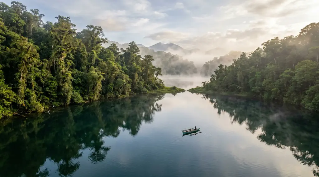
In the mountains behind Sibulan, about 20 kilometers north of Dumaguete, two crater lakes sit in a protected natural park: Lake Balinsasayao and Lake Danao. The road to reach them climbs through agricultural land and then into forest, and the lakes appear below a ridge with the abruptness that characterizes this kind of mountain terrain. Both lakes are deep, clear, and surrounded by forest that has been under community protection since the 1990s, one of the earlier and more successful examples of community-based conservation in the Philippines.
The Balinsasayao Twin Lakes Natural Park is managed by the local government of Sibulan in partnership with the communities around the lakes. Kayaks are available for rent on Lake Balinsasayao. Hiking trails circle both lakes and connect to viewpoints above the ridge. The forests around the lakes are among the better birdwatching sites in Negros Oriental; several endemic species use the forest interior here, and the elevation (around 800 meters) means the temperature is noticeably cooler than the coast. This is a place worth spending a full day, not just an afternoon.
Lake Balanan
Lake Balanan, in the municipality of La Castellana in Negros Occidental, has an unusual origin. It was created by a tectonic earthquake in the early 20th century that blocked a river valley, impounding water behind a natural dam. The resulting lake is relatively shallow but covers a significant area, with three small islands on its surface. It is less visited than Balinsasayao; its position in the western lowlands means it offers less scenic drama than the crater lakes, but it supports a resident bird population that attracts local birdwatchers, and its fishing is productive. For travelers who want to get off the standard Negros Occidental circuit, it is an under-visited option.
Mabinay Spring
Mabinay Spring is the surface manifestation of the karst water system that underlies the Mabinay cave network. The main pool is large, fed continuously by the underground source, and cold in the way that only groundwater emerging from limestone can be cold, a temperature difference from the ambient air that is immediately noticeable. The spring is set in grounds developed as a local recreation area, with covered picnic areas, swimming access, and basic infrastructure that makes the natural spring usable for families. It is not a remote wilderness experience. It is a very good swimming hole, fed by a karst system that has been moving water through limestone formations for millions of years, and it is the best place to understand what the ground under Mabinay actually does with the rainfall it receives.
The North Negros Natural Park — What the Island Protects
The North Negros Natural Park (NNNP) covers the mountain forest of northern Negros Occidental, centered on Mt. Mandalagan and Mt. Silay. It is one of the most important protected areas in the Philippines for endemic species, species found nowhere else on Earth, and one of the least publicized outside birdwatching and conservation circles.
The park’s flagship species is the Negros Bleeding-heart Dove, a ground-foraging bird with a vivid blood-red patch on its breast that appears to be a wound. The effect is arresting, which is presumably not the evolutionary intention. The species is critically endangered due to habitat loss from decades of agricultural expansion up the mountain slopes, and the NNNP represents one of the last significant forest blocks it can use. Also present: the Visayan Warty Pig, the Negros Striped-Babbler, the Visayan Spotted Deer, and the Philippine Tube-nosed Fruit Bat, all endemic to the Visayas and under varying degrees of threat.
The Conservation Picture
The conservation picture on Negros Island is not uniformly positive. The island lost the majority of its original forest cover over the course of the 19th and 20th centuries, primarily to agricultural expansion driven by the sugar economy in Negros Occidental and small-scale farming in the highlands of both provinces. What remains is significant but fragmented. The park system, Kanlaon Natural Park, North Negros Natural Park, and the protected areas around Balinsasayao, preserve the most intact fragments. Reforestation programs are active in both provinces, and community-based conservation arrangements have had measurable success in reducing hunting pressure on endemic species. The trajectory is not hopeless. It is not comfortable, either.
For visitors interested in the natural wonders of Negros Island in a more than superficial way, the NNNP is worth the additional logistics. Guided birding trips can be arranged through conservation organizations operating in the northern Negros Occidental area. The trails in the park are not developed for casual tourism, and that is partly the point. The forest that remains here is intact precisely because it has not been made easy to visit.
The Coastline and What It Contains
Negros Island has more than 500 kilometers of coastline between its two provinces, ranging from the built-up waterfront of Bacolod and Dumaguete through fishing villages and black-sand beaches to the southern tip of Negros Occidental, where the island tapers toward the Sulu Sea. The marine environment off Negros Island is covered in depth in the companion article on ocean and marine life, but a few features are worth noting here in the context of the island’s natural wonders.
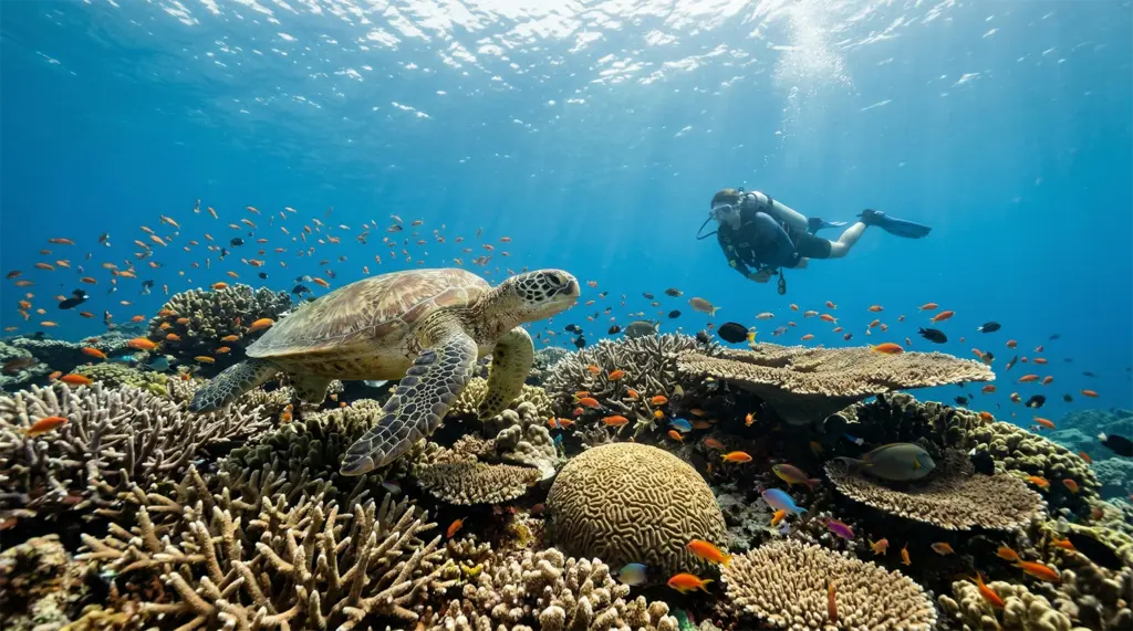
Apo Island, a small volcanic island off the southeastern tip of Negros Oriental, is one of the most celebrated marine conservation success stories in Southeast Asia. The community-managed marine sanctuary established in the 1980s allowed the reef system to recover from overfishing to the point where it now supports one of the densest populations of large reef fish in the Philippines. The island also has a resident population of green sea turtles that can be encountered on almost every dive. Full coverage of Apo Island and the marine environment is in the ocean and marine life article in this series.
The mangrove systems along the Negros Occidental coast and in several estuarine areas of Negros Oriental provide nursery habitat for fish species that support both the local fishing economy and the coral reef ecosystems offshore. They are not as dramatic as Kanlaon, but they are ecologically functional in ways that the more spectacular natural features depend on; the fish in the reef at Apo Island do not appear out of nowhere. They come from nursery systems like these.
The Negros Island Series — What Follows This Article
Negros Island is one of those destinations that resists a single article. The island is large enough, varied enough, and historically layered enough that a traveler who reads only one piece about it before arriving will miss the larger picture, and the larger picture is worth having before the flight lands.
This article is part of a five-piece series covering Negros Island in full. The history article traces everything from the pre-colonial Ati and Bukidnon communities through the Spanish sugar economy, the 1898 Cantonal Republic of Negros, the American chapter, and the sugar crisis of the 1980s that produced the MassKara Festival, a context that makes the hacienda architecture, the festival culture, and the social character of Bacolod and Dumaguete considerably more readable on the ground. The natural wonders article (this article) covers Mt. Kanlaon and the broader volcanic landscape, the Mabinay cave systems, the waterfalls of Negros Oriental, the Twin Lakes of Balinsasayao, and the endemic species of the North Negros Natural Park.
The culture article examines the language divide between the two provinces, the full story of MassKara and Buglasan, the food traditions of both coasts, the ancestral home architecture of Silay City, and the literary culture that Silliman University has sustained in Dumaguete for more than a century. The ocean and marine life article delves into Apo Island’s community conservation story, the muck-diving coast at Dauin, and the cetacean corridors of the Taon Strait. The overview article is the practical planning piece: the two-province decision, how to get there and between them, when to visit, and which province to base yourself in, depending on what you are looking for.
The Takeaway
Read together, the five articles cover the island the way it deserves to be covered. Read individually, each one stands on its own. Either approach works, but the traveler who arrives knowing the history, ecology, culture, and marine environment will find that Negros Island gives back more than it asks.
Frequently Asked Questions About the Natural Wonders of Negros Island
Q1: Is Mt. Kanlaon safe to visit?
Mt. Kanlaon is an active stratovolcano with a history of eruptions, most recently in 2016 and subsequent years. The mountain is open for trekking when the Philippine Institute of Volcanology and Seismology (PHIVOLCS) has it at Alert Level 0, meaning normal background activity. Always check with PHIVOLCS before planning a visit here. This is an active volcano, and at the time of this writing, it is very active and must be regarded as such. When the alert level rises (as it does with some regularity), summit access is suspended, and hikers are advised to stay away from the crater area. Always check the current PHIVOLCS status before planning a visit to Kanlaon. The natural park itself and its lower trails may remain accessible when the summit is closed, depending on the specific alert conditions. Permits are required for all trekking in the natural park.
Q2: How do I get to the Mabinay caves in Negros Oriental?
Mabinay is in the interior of Negros Oriental, roughly 70 kilometers north of Dumaguete. The town is accessible by bus from Dumaguete, but having your own transport, a rented motorcycle or car, makes the visit to the cave significantly more flexible. The caves closest to the town center are the most accessible and can be visited with a locally arranged guide. Ask at the Mabinay municipal tourism office for current cave access information and to arrange a guide; the cave systems are extensive enough that going in without one is not advisable. Plan at least half a day for the caves alone; Mabinay Spring and the surrounding karst landscape warrant a full day.
Q3: What is the best waterfall to visit on Negros Island?
For most visitors to Negros Oriental, Casaroro Falls near Valencia (about 15 kilometers from Dumaguete) is the most accessible and most rewarding waterfall. The 30-meter drop is dramatic, the pool is swimmable in the dry season, and the approach through the secondary forest is pleasant. For something more unusual, Pulangbato Falls, also near Valencia, is the more distinctive choice: the volcanic mineral content has colored the surrounding rock a deep orange-red, and the warm water pools are unlike any other waterfall in the Philippines. On the Negros Occidental side, Bugsok Falls near Kabankalan is a good option for travelers working the western coast. Most waterfall sites require a guide and some trekking; plan for a half day minimum.
Q4: What endemic species can I see in the North Negros Natural Park?
The North Negros Natural Park is one of the most important sites in the Philippines for Visayan endemic species. Target species for birders include the Negros Bleeding-heart Dove (critically endangered; blood-red breast marking), the Negros Striped-Babbler (endemic to Negros Island), and the Visayan Hornbill. Mammals include the Visayan Warty Pig and the Visayan Spotted Deer, both of which are critically endangered. Access to the park’s interior is best done with an experienced local guide or through conservation organizations working in the northern Negros Occidental area. The park infrastructure is not developed for casual tourism, which is partly why the endemic species have survived there.
Q5: When is the best time to visit the natural wonders of Negros Island?
The dry season, roughly November through May, is generally the best time to visit most of Negros Island’s natural attractions. Waterfall trails are safer, the Kanlaon summit is more reliably accessible (weather permitting and volcanic activity aside), and the Mabinay caves are easier to navigate. The Twin Lakes of Balinsasayao are accessible year-round, but the forest trails around them are slippery in heavy rain. Note that Negros Occidental and Negros Oriental have somewhat different rainfall patterns due to the mountain spine: the western province receives more rain from June through October (the southwest monsoon side), while the eastern province is drier from June through October and wetter from November through January. Plan accordingly depending on which province you are visiting.
SUGGESTIONS FOR LODGING AND TRAVEL
Lodging is widely available throughout the Philippines. However, you may want to get some assistance booking tours to some of the Philippines’ attractions. I’ve provided a few local agencies that we’ve found to be very good for setting up tours. For transparency: We may earn a commission when you click on certain links in this article, but this doesn’t influence our editorial standards. We only recommend services that we genuinely believe will enhance your travel experiences. This will not cost you anything, and I can continue to support this site through these links.
- For Hotel Accommodations in the Manila area, I highly recommend The Manila Hotel. It is centrally located and within walking distance of Rizal Park and Intramuros. Many other attractions are easily accessible from there as well. I have provided a search box below for you to find hotels (click on “Stays” at the top) or flights (click on “Flights” at the top). This tool will provide me with an affiliate commission (at no cost to you).
Local Travel & Lodging Assistance
- Guide to the Philippines: This site specializes in tours throughout the Philippines. They seem to have some flexibility in scheduling, and pricing is very competitive.
- Kapwa Travel is a travel company focused on the Philippines. It specializes in customizing trips to meet customers’ needs.
- Tourismo Filipino is a well-established company that has operated for over 40 years. It focuses on tailoring tours to meet customers’ needs.
- Tropical Experience Travel Services – Tours of the Philippines: This company offers a range of tour packages, allowing you to tailor your trip to your preferences.
Specific Lodging Suggestions
- Big BamBoo Beach Resort Sipalay – This is a moderately priced resort in Sipalay, Negros Oriental, with great beach access.
- Hotel Dumaguete – A very nice hotel with good reviews and reasonably priced.
- Rovira Suites in Dumaguete – A very nice hotel with very good reviews and a very reasonable price.
- Citadines Bacolod City – A highly rated and popular hotel in the Bacolod area. A little pricier than some, but worth the cost.
- Stonehill Suites – Another highly rated hotel in the Bacolod area. This one is a little more reasonably priced.
- Circle Inn – Hotel & Suites – This hotel falls into the budget-friendly category. They, too, are well-rated and provide good, comfortable lodging.
Lastly, we recommend booking international travel flights through established organizations rather than a local travel agent in the Philippines. I recommend Expedia.com (see the box below), the site I use to book my international travel. I have provided a search box below for you to use to search for flights (click on “Flights” at the top) or Hotels (click on “Stays” at the top). This tool will provide me with an affiliate commission (at no cost to you).